Aosta Valley Summer guided hiking
VALLE D’AOSTA day HIKES & OBJECTIVES
Difficulty Scale:
1 = Easy walks
2 = Easy–Moderate hiking
3 = Moderate mountain hiking
4 = Challenging alpine hiking
5 = Advanced alpine objectives
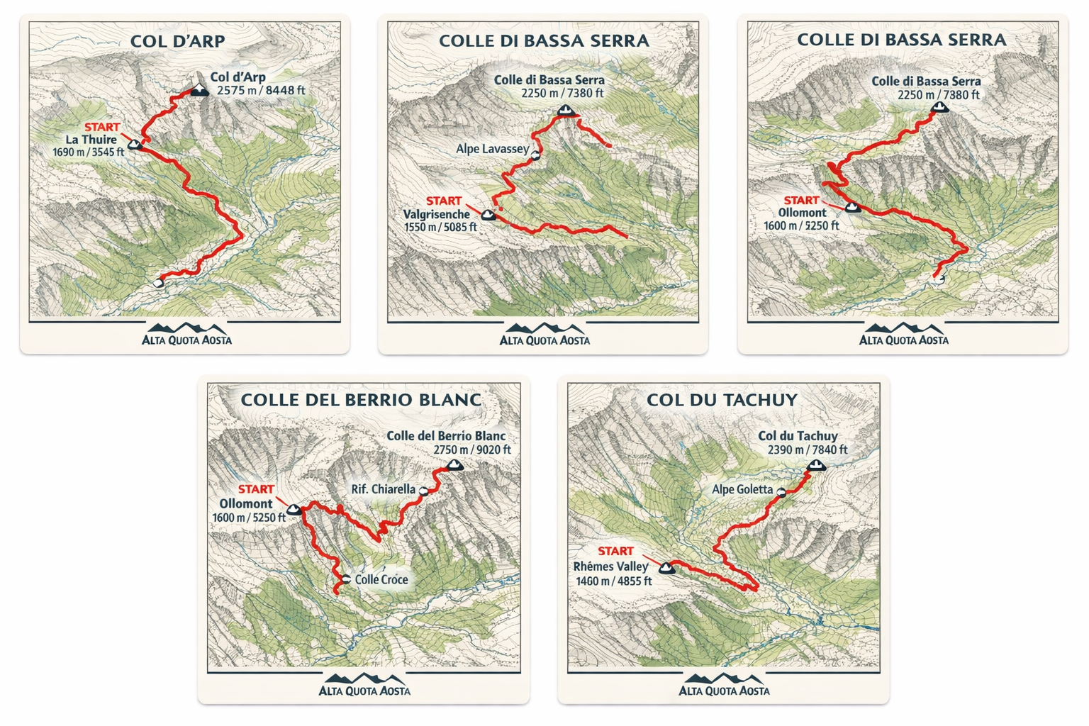
Col d’Arp (Start: ~1,700 m / 5,575 ft)
Difficulty: 3 / 5
Days/Time: 4–6 hrs
Total Distance: ~10 km / 6.2 mi
Total Vertical: ~750 m / 2,460 ft
Closest departure town: La Thuile / Morgex
Short description: A classic high pass between valleys with wide alpine views and gentle terrain, ideal for strong walkers seeking a scenic half-day outing.
Colle di Bassa Serra (Start: ~1,850 m / 6,070 ft)
Difficulty: 4 / 5
Days/Time: 5–7 hrs
Total Distance: ~11 km / 6.8 mi
Total Vertical: ~1,000 m / 3,280 ft
Closest departure town: Valgrisenche
Short description: A remote and rewarding alpine crossing with expansive ridge views and a true wilderness feel.
Colle del Berrio Blanc (Start: ~1,900 m / 6,230 ft)
Difficulty: 4 / 5
Days/Time: 6–8 hrs
Total Distance: ~12 km / 7.5 mi
Total Vertical: ~1,100 m / 3,610 ft
Closest departure town: Valpelline
Short description: A wild high pass linking dramatic glacial valleys, best suited for experienced hikers seeking solitude and big landscapes.
Punta Lancebranlette (Start: ~1,850 m / 6,070 ft)
Difficulty: 5 / 5
Days/Time: 6–8 hrs
Total Distance: ~10 km / 6.2 mi
Total Vertical: ~1,200 m / 3,940 ft
Closest departure town: Valpelline
Short description: A panoramic summit ascent offering wide views over the Mont Blanc massif and surrounding valleys.
Col du Tachuy (Start: ~1,750 m / 5,740 ft)
Difficulty: 3 / 5
Days/Time: 5–7 hrs
Total Distance: ~11 km / 6.8 mi
Total Vertical: ~850 m / 2,790 ft
Closest departure town: Valpelline
Short description: A scenic high mountain pass with broad meadows, rocky ridgelines, and far-reaching alpine views.
Laghi di Bellacomba (Start: ~1,700 m / 5,575 ft)
Difficulty: 3 / 5
Days/Time: 4–6 hrs
Total Distance: ~9 km / 5.6 mi
Total Vertical: ~650 m / 2,130 ft
Closest departure town: Valgrisenche
Short description: A beautiful lake basin hike through alpine pastures and wild granite terrain, perfect for relaxed exploration days.
Colle di Passo Alto (Start: ~1,950 m / 6,400 ft)
Difficulty: 5 / 5
Days/Time: 7–9 hrs
Total Distance: ~13 km / 8.1 mi
Total Vertical: ~1,200 m / 3,940 ft
Closest departure town: Valgrisenche / Rhêmes Valley
Short description: A demanding high-altitude crossing between valleys, offering vast glacial views and true alpine character.
Becca Pougnenta (Start: ~1,850 m / 6,070 ft)
Difficulty: 5 / 5
Days/Time: 6–8 hrs
Total Distance: ~9 km / 5.6 mi
Total Vertical: ~1,250 m / 4,100 ft
Closest departure town: Valgrisenche
Short description: A steep summit hike with exceptional panoramic rewards, ideal for strong hikers seeking a peak experience.
Bivacco Fiorio (Start: ~1,750 m / 5,740 ft)
Difficulty: 3 / 5
Days/Time: 4–6 hrs
Total Distance: ~8 km / 5.0 mi
Total Vertical: ~700 m / 2,300 ft
Closest departure town: Valgrisenche
Short description: A scenic approach to a remote high bivouac overlooking glaciers and alpine basins.
Bivacco Comino (Start: ~1,850 m / 6,070 ft)
Difficulty: 4 / 5
Days/Time: 5–7 hrs
Total Distance: ~9 km / 5.6 mi
Total Vertical: ~900 m / 2,950 ft
Closest departure town: Valpelline
Short description: A beautiful high route to a perched bivouac with expansive views across wild mountain terrain.
Col de Malatrà (Start: ~1,600 m / 5,250 ft)
Difficulty: 4 / 5
Days/Time: 6–8 hrs
Total Distance: ~13 km / 8.1 mi
Total Vertical: ~1,050 m / 3,445 ft
Closest departure town: Val Ferret / Courmayeur
Short description: A legendary alpine pass on the Tour du Mont Blanc with wide open views over Mont Blanc and Val Ferret.
Testa di Liconi (Start: ~1,900 m / 6,230 ft)
Difficulty: 5 / 5
Days/Time: 7–9 hrs
Total Distance: ~11 km / 6.8 mi
Total Vertical: ~1,300 m / 4,265 ft
Closest departure town: Valpelline
Short description: A remote summit ascent with sweeping glacial panoramas and a true high-mountain atmosphere.
Bivacco Cosimo Zappelli (Start: ~1,850 m / 6,070 ft)
Difficulty: 4 / 5
Days/Time: 6–8 hrs
Total Distance: ~10 km / 6.2 mi
Total Vertical: ~1,000 m / 3,280 ft
Closest departure town: Valpelline
Short description: A wild and scenic route to a high alpine bivouac set among glaciers and granite peaks.
Mont de l’Âne (Start: ~1,750 m / 5,740 ft)
Difficulty: 3 / 5
Days/Time: 5–7 hrs
Total Distance: ~10 km / 6.2 mi
Total Vertical: ~850 m / 2,790 ft
Closest departure town: Valgrisenche
Short description: A grassy summit with broad alpine views, ideal for strong walkers seeking a quieter alternative to major peaks.
Rifugio degli Angeli (Start: ~1,700 m / 5,575 ft)
Difficulty: 2 / 5
Days/Time: 3–5 hrs
Total Distance: ~7 km / 4.3 mi
Total Vertical: ~600 m / 1,970 ft
Closest departure town: Valpelline
Short description: A scenic hut hike through high pastures to a welcoming refuge with sweeping valley views.
Arp Vieille (Start: ~1,900 m / 6,230 ft)
Difficulty: 2 / 5
Days/Time: 2–4 hrs
Total Distance: ~6 km / 3.7 mi
Total Vertical: ~400 m / 1,310 ft
Closest departure town: La Thuile
Short description: A gentle alpine walk through meadows and traditional pastureland, ideal for relaxed half-day outings.
Colle di Cussunaz (Start: ~1,850 m / 6,070 ft)
Difficulty: 4 / 5
Days/Time: 6–8 hrs
Total Distance: ~12 km / 7.5 mi
Total Vertical: ~1,050 m / 3,445 ft
Closest departure town: Valgrisenche
Short description: A high mountain crossing between remote valleys with broad ridgeline views and quiet landscapes.
Lago Tormottaz (Start: ~1,750 m / 5,740 ft)
Difficulty: 3 / 5
Days/Time: 4–6 hrs
Total Distance: ~9 km / 5.6 mi
Total Vertical: ~650 m / 2,130 ft
Closest departure town: Valgrisenche
Short description: A peaceful alpine lake hike through open terrain and wild mountain scenery.
Vallone di Thuilette (Start: ~1,600 m / 5,250 ft)
Difficulty: 2 / 5
Days/Time: 3–5 hrs
Total Distance: ~7 km / 4.3 mi
Total Vertical: ~450 m / 1,475 ft
Closest departure town: La Thuile
Short description: A wide valley walk following alpine streams and meadows, ideal for acclimatization or relaxed days.
Rifugio Deffeyes (Start: ~1,600 m / 5,250 ft)
Difficulty: 3 / 5
Days/Time: 4–6 hrs
Total Distance: ~8 km / 5.0 mi
Total Vertical: ~700 m / 2,300 ft
Closest departure town: La Thuile
Short description: A classic refuge hike through waterfalls and alpine terrain with rewarding mountain views.
Colle della Croce (Start: ~1,700 m / 5,575 ft)
Difficulty: 3 / 5
Days/Time: 5–7 hrs
Total Distance: ~11 km / 6.8 mi
Total Vertical: ~850 m / 2,790 ft
Closest departure town: La Thuile / Valgrisenche
Short description: A scenic high pass connecting valleys, offering open ridgelines and broad panoramas.
Lago d’Arpy (Start: ~2,000 m / 6,560 ft)
Difficulty: 1 / 5
Days/Time: 1–2 hrs
Total Distance: ~3 km / 1.9 mi
Total Vertical: ~150 m / 490 ft
Closest departure town: La Thuile
Short description: A beautiful alpine lake stroll with dramatic Mont Blanc views — accessible and highly photogenic.
Lago Verney (Start: ~2,000 m / 6,560 ft)
Difficulty: 2 / 5
Days/Time: 2–3 hrs
Total Distance: ~5 km / 3.1 mi
Total Vertical: ~300 m / 985 ft
Closest departure town: Val Ferret
Short description: A tranquil lakeside walk beneath glaciers and high peaks, ideal for relaxed exploration.
Cascate del Rutor (Start: ~1,700 m / 5,575 ft)
Difficulty: 2 / 5
Days/Time: 2–4 hrs
Total Distance: ~6 km / 3.7 mi
Total Vertical: ~350 m / 1,150 ft
Closest departure town: La Thuile
Short description: A spectacular waterfall circuit with bridges, viewpoints, and lush alpine scenery.
Col du Petit Ferret (Start: ~1,700 m / 5,575 ft)
Difficulty: 3 / 5
Days/Time: 4–6 hrs
Total Distance: ~10 km / 6.2 mi
Total Vertical: ~700 m / 2,300 ft
Closest departure town: Val Ferret / Courmayeur
Short description: A wide and scenic international alpine pass offering views across Mont Blanc into Switzerland.
Col de la Seigne (Start: ~1,900 m / 6,230 ft)
Difficulty: 3 / 5
Days/Time: 4–6 hrs
Total Distance: ~11 km / 6.8 mi
Total Vertical: ~650 m / 2,130 ft
Closest departure town: Val Veny / Courmayeur
Short description: A beautiful and accessible high pass on the Tour du Mont Blanc with expansive glacier views.
Lago del Miage (Start: ~1,600 m / 5,250 ft)
Difficulty: 2 / 5
Days/Time: 2–4 hrs
Total Distance: ~6 km / 3.7 mi
Total Vertical: ~300 m / 985 ft
Closest departure town: Val Veny / Courmayeur
Short description: A stunning glacial lake walk beneath the Mont Blanc massif, suitable for a relaxed half day.
Rifugio Bonatti (Start: ~1,600 m / 5,250 ft)
Difficulty: 3 / 5
Days/Time: 3–5 hrs
Total Distance: ~7 km / 4.3 mi
Total Vertical: ~550 m / 1,805 ft
Closest departure town: Val Ferret / Courmayeur
Short description: A classic balcony trail to one of the most scenic refuges in the Alps overlooking Mont Blanc.
Col Serena (Start: ~1,800 m / 5,905 ft)
Difficulty: 3 / 5
Days/Time: 4–6 hrs
Total Distance: ~9 km / 5.6 mi
Total Vertical: ~650 m / 2,130 ft
Closest departure town: Valgrisenche
Short description: A quiet alpine pass with open terrain and sweeping valley views.
Punta Fetita (Start: ~1,900 m / 6,230 ft)
Difficulty: 4 / 5
Days/Time: 6–8 hrs
Total Distance: ~10 km / 6.2 mi
Total Vertical: ~1,100 m / 3,610 ft
Closest departure town: Valgrisenche
Short description: A rewarding summit route offering wide alpine panoramas and a sense of remoteness.
Belvedere della Brenva (2173 m) (Start: ~1,700 m / 5,575 ft)
Difficulty: 2 / 5
Days/Time: 2–4 hrs
Total Distance: ~5 km / 3.1 mi
Total Vertical: ~350 m / 1,150 ft
Closest departure town: Val Veny / Courmayeur
Short description: A spectacular viewpoint hike overlooking the Brenva Glacier and Mont Blanc’s southern face.
Skyway Monte Bianco Experience (Start: ~1,300 m / 4,265 ft)
Difficulty: 1 / 5
Days/Time: 2–4 hrs
Total Distance: Variable walking
Total Vertical: Lift-assisted
Closest departure town: Courmayeur
Short description: Cable car ascent to Punta Helbronner with optional high-altitude walks and panoramic glacier viewpoints.
Lago di Fond (Start: ~1,750 m / 5,740 ft)
Difficulty: 3 / 5
Days/Time: 3–5 hrs
Total Distance: ~7 km / 4.3 mi
Total Vertical: ~500 m / 1,640 ft
Closest departure town: Valgrisenche
Short description: A quiet alpine lake hike through open pastureland and mountain terrain.
Becca Ceré (Start: ~1,850 m / 6,070 ft)
Difficulty: 5 / 5
Days/Time: 6–8 hrs
Total Distance: ~10 km / 6.2 mi
Total Vertical: ~1,200 m / 3,940 ft
Closest departure town: Rhêmes Valley
Short description: A striking summit hike offering wide-ranging views across Gran Paradiso terrain.
Rifugio Bezzi (Start: ~1,700 m / 5,575 ft)
Difficulty: 3 / 5
Days/Time: 4–6 hrs
Total Distance: ~8 km / 5.0 mi
Total Vertical: ~700 m / 2,300 ft
Closest departure town: Valgrisenche
Short description: A classic refuge hike through alpine basins beneath glaciers and rugged peaks.
Giardino Botanico Alpino (Chanousia) (Start: ~2,150 m / 7,050 ft)
Difficulty: 1 / 5
Days/Time: 1–2 hrs
Total Distance: ~2 km / 1.2 mi
Total Vertical: ~50 m / 165 ft
Closest departure town: Little St Bernard Pass / La Thuile
Short description: A gentle alpine garden walk showcasing high-altitude flora in a stunning mountain setting.
Col du Mont (Start: ~1,900 m / 6,230 ft)
Difficulty: 3 / 5
Days/Time: 4–6 hrs
Total Distance: ~10 km / 6.2 mi
Total Vertical: ~700 m / 2,300 ft
Closest departure town: La Thuile / Valgrisenche
Short description: A scenic high pass between Italy and France with wide open alpine views.
Alpeggio di Arp Vieille (Start: ~1,900 m / 6,230 ft)
Difficulty: 1 / 5
Days/Time: 2–4 hrs
Total Distance: ~5 km / 3.1 mi
Total Vertical: ~300 m / 985 ft
Closest departure town: La Thuile
Short description: A relaxed walk through traditional alpine pastureland to historic mountain farms.
Alpe Mont Forchat (Start: ~1,750 m / 5,740 ft)
Difficulty: 2 / 5
Days/Time: 3–5 hrs
Total Distance: ~7 km / 4.3 mi
Total Vertical: ~450 m / 1,475 ft
Closest departure town: Valpelline
Short description: A scenic pastoral hike through open meadows with panoramic valley views.
Summer Hiking Difficulty Guide
This guide is designed to help you choose hikes that match your comfort level, movement style, and desired experience.
There is no “better” or “worse” category—each level simply reflects different terrain, pace, and technical elements.
Our guides are always happy to adjust routes in real time.
🌿 Level 1 — Valley Walks & Scenic Paths
Relaxed, immersive, and unhurried
Best for guests who:
Enjoy walking for scenery, conversation, and nature
Prefer wide paths and gentle terrain
Want flexibility for stops, photos, and cafés or refugios
Terrain & Experience:
Well-maintained trails, valley floors, historic paths
Minimal elevation change
No exposure or technical footing
Typical Day:
1.5–3 hours of walking
Frequent pauses and optional extensions
Ideal as a recovery day or introduction to the region
🌲 Level 2 — Alpine Trails & Refugio Routes
Engaging hiking with moderate effort
Best for guests who:
Regularly hike or walk on uneven ground
Are comfortable with steady uphill sections
Want a sense of achievement without pressure
Terrain & Experience:
Mountain trails, forest paths, alpine meadows
Moderate elevation gain
Occasional rocky or narrow sections, no sustained exposure
Typical Day:
3–5 hours on trail
Refugio lunch or destination-based routes
Balanced pace with scenic rests
⛰ Level 3 — High Alpine Routes
Dynamic terrain with increased awareness
Best for guests who:
Hike frequently in mountainous environments
Are comfortable with sustained climbs and descents
Move confidently on rocky or uneven terrain
Terrain & Experience:
Steeper alpine trails above treeline
Rock slabs, scree, and uneven footing
Some exposed sections requiring focus (hands may be used occasionally)
Typical Day:
4–6 hours on trail
Noticeable elevation gain
A strong alpine feel with wide views and quieter paths
🧗 Level 4 — Technical Alpine Hiking
Purposeful movement in committed terrain
Best for guests who:
Have prior alpine hiking or mountaineering experience
Are comfortable with exposure and route-finding
Enjoy physically and mentally engaging days
Terrain & Experience:
Steep, rocky terrain with exposure
Scrambling, chains, or fixed cables may be present
Sure-footed movement required
Typical Day:
5–7 hours
Significant elevation gain
Routes selected carefully based on weather and conditions
Safety equipment may be recommended depending on route.
🏔 Level 5 — Advanced Alpine Objectives
Serious terrain for experienced mountain travelers
Best for guests who:
Regularly operate in high alpine environments
Are confident with exposure, scrambling, and variable conditions
Understand that plans may change based on safety considerations
Terrain & Experience:
Highly exposed ridgelines or remote terrain
Sustained scrambling or technical movement
Full mountain awareness required
Typical Day:
Long, demanding days
Early starts and flexible objectives
Guide discretion is essential
A Note on Choosing Your Level
Many guests comfortably enjoy multiple levels within one week.
Your guide will:
Adjust pace, distance, and terrain
Offer optional variations
Prioritize enjoyment, safety, and conditions over labels
If you’re unsure, choose the level that feels comfortably achievable, not aspirational. There is always room to step up once you’re here.